GEOTECHNICALENGINEERING
RED DEER
HomeUnderground ExcavationsGeotechnical analysis for soft soil tunnels

Geotechnical Analysis for Soft Ground Tunnels in Red Deer

Sound ground. Sound decisions.

LEARN MORE

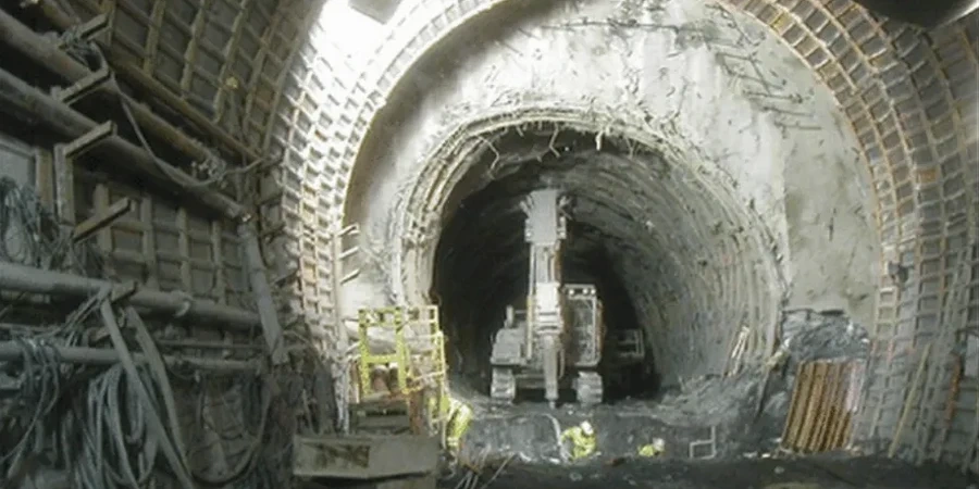
A recent river crossing project near the Red Deer River required tunneling through saturated silts with less than 15 kPa undrained shear strength—material that flows like toothpaste under pressure. The contractor faced face losses twice before we were brought in to redesign the geotechnical baseline. Soft ground tunneling in central Alberta demands a testing program that captures the transition from glacial lake deposits to the underlying bedrock, because missing that contact zone during a borehole campaign creates a risk profile no contractor should carry. Our laboratory handles the full suite of ASTM and CSA-compatible tests to generate parameters for numerical models, face pressure calculations, and settlement trough predictions. We routinely coordinate with drilling crews operating along the QEII corridor and within Red Deer’s river valley, where the CPT testing data often reveals thin sand lenses that conventional SPT sampling misses entirely, and where grain size analysis of the till matrix helps define the abrasivity index for cutterhead selection.

The contact between soft glaciolacustrine silt and Paskapoo shale in Red Deer can shift the required face pressure by 80 kPa over less than two meters of vertical advance.

Our service areas

Methodology and scope

Red Deer sits at roughly 855 meters elevation within a complex Quaternary stratigraphy that includes advance-phase glaciolacustrine silts, clay tills, and preglacial gravels. The city’s population now exceeds 100,000, pushing infrastructure into areas where the soft soil thickness varies from 3 meters on the uplands to over 30 meters in the buried valley near the downtown core. For EPB tunneling through these deposits, we derive the undrained shear strength from consolidated undrained triaxial testing with pore pressure measurement, then cross-reference those values with field vane data to bracket the operational range for face support pressure. When the alignment crosses into the Paskapoo Formation bedrock, a completely different set of parameters governs cutter wear and advance rate, so we often recommend Atterberg limits testing on the weathered shale transition zone to quantify the plasticity change that signals the contact. The laboratory program we design for Red Deer projects follows CSA A23.3 guidelines for concrete segments and ASTM D4767 for triaxial procedures, ensuring every parameter submitted to the tunnel designer is defensible under third-party review.
Geotechnical Analysis for Soft Ground Tunnels in Red Deer
Technical reference — Red Deer

Site-specific factors

The north side of Red Deer, developed on higher glacial till terrain, presents a fundamentally different tunneling risk than the river valley south of Taylor Drive. Upland tills are overconsolidated and tend to stand unsupported for short periods; the valley deposits are normally consolidated, highly sensitive, and lose structure rapidly under remolding. We observed this contrast on a recent sewer tunnel where the alignment crossed from the till upland into the buried valley—the face pressure required a 60 kPa increase within a single ring advance to control extrusion. The second major risk factor is the groundwater regime. The Red Deer River sustains a high water table across the floodplain, and any drop in face pressure below hydrostatic triggers immediate inflow. Our testing program quantifies the remolded strength and the sensitivity ratio specifically for this scenario, because both parameters feed directly into the stability assessment of the unsupported span at the cutterhead.

Need a geotechnical assessment?

Reply within 24h.

Email: info@geotechnicalengineering.xyz

Applicable standards

NBCC 2020 (National Building Code of Canada), CSA A23.3:19 (Design of Concrete Structures), ASTM D4767-11 (Consolidated Undrained Triaxial), ASTM D4318-17e1 (Atterberg Limits), ASTM D2487-17e1 (Unified Soil Classification)

Technical data

ParameterTypical value
Undrained shear strength (Su)10–80 kPa (soft to firm)
Plasticity index (PI)8–35%
Overconsolidation ratio (OCR)1.2–3.5
Permeability (k)10⁻⁷ to 10⁻⁹ m/s
Effective friction angle (φ')24°–32°
Compression index (Cc)0.15–0.45
Soil abrasivity index (SAI)0.8–2.6

Frequently asked questions

What is the typical cost range for a soft ground tunnel geotechnical analysis in Red Deer?

For a comprehensive laboratory program covering GBR parameters, face stability, and segment lining compatibility, the analysis typically ranges from CA$6,410 to CA$22,310, depending on the number of soil units, the depth of sampling, and whether specialized abrasivity or consolidation testing is required.

Which soil parameters are most critical for EPB tunnel design in Red Deer's geology?

Undrained shear strength and sensitivity are the primary parameters for face pressure control, particularly in the glaciolacustrine silts of the buried valley. Permeability and the grain size distribution determine the conditioning requirements, while the overconsolidation ratio influences the long-term settlement trough shape.

How do you handle the transition zone between soft soil and Paskapoo bedrock?

We sample intensively across the contact—typically at 0.5 m intervals—and run Atterberg limits and point load tests to map the weathering profile. The transition material often behaves as a completely weathered shale with plasticity index values between 10% and 25%, requiring a mixed-face EPB operating mode.

What ASTM standards apply to triaxial testing for tunnel design?

We follow ASTM D4767 for consolidated undrained triaxial compression tests with pore pressure measurement on cohesive soils, and ASTM D2850 for unconsolidated undrained tests on weaker materials where rapid turnaround is needed. All testing is compatible with the parameter formats required by NBCC 2020 and the geotechnical baseline report framework.

Location and service area

We serve projects in Red Deer and surrounding areas.

View larger map