GEOTECHNICALENGINEERING
RED DEER
HomeLaboratoryGrain size analysis (sieve + hydrometer)

Grain Size Analysis (Sieve + Hydrometer) in Red Deer

Sound ground. Sound decisions.

LEARN MORE

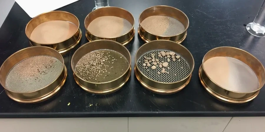
The Ro-Tap sieve shaker runs through a full nest of 8-inch brass sieves while the hydrometer cylinder settles in a temperature-controlled water bath. In our Red Deer lab, grain size analysis combines these two methods to build the full particle size distribution curve, from coarse gravel down to clay colloids smaller than 2 microns. A sample splitter divides the air-dried material before washing over the No. 200 sieve. The retained fraction goes into the mechanical shaker stack, and the fines passing through get dispersed with sodium hexametaphosphate for the sedimentation phase. Red Deer projects frequently encounter glacial till and alluvial deposits along the Red Deer River that demand this combined approach. The hydrometer readings at 15 seconds, 30 seconds, 1 minute, 2 minutes, 4 minutes, and onward capture the settlement rate of silt and clay fractions.
When the gradation curve reveals a gap-graded or poorly graded soil, we often recommend pairing the results with an Atterberg limits evaluation to determine whether the fine fraction behaves as a plastic clay or a non-plastic silt. For deeper investigation of the bearing stratum below the surficial clays, a CPT test program can map the stratigraphic continuity across the site without disturbing the sample structure.

A single hydrometer test reveals more about drainage and frost behavior in Red Deer silts than a dozen compaction curves on their own.

Our service areas

Methodology and scope

The surficial geology beneath Red Deer is dominated by glacial Lake Calgary sediments and postglacial alluvial terraces along the Red Deer River. These deposits often contain interbedded silts, clays, and fine sands that defy classification by sieve analysis alone. The hydrometer method resolves the silt-clay boundary at 0.075 mm, while the finest sieves in the stack—typically the No. 100 and No. 200—handle the sand fraction. A composite curve stitches the two data sets together at the overlap point, producing a single continuous gradation plot.
For road base and subgrade evaluations in Red Deer's Queens Business Park or Edgar Industrial Area, the gradation directly informs compaction specifications and drainage design. The uniformity coefficient (Cu) and coefficient of curvature (Cc) calculated from the curve classify the soil under the Unified Soil Classification System, which governs everything from filter design to frost susceptibility ratings. On sites where the near-surface clay layer exceeds 3 meters, we combine the grain size data with an SPT drilling program to correlate gradation shifts with blow count changes at depth. Laboratory quality control follows ASTM D422 and D6913 procedures, with oven-dried specimens weighed to 0.01 g precision on calibrated balances.

Grain Size Analysis (Sieve + Hydrometer) in Red Deer
Technical reference — Red Deer

Site-specific factors

A foundation on the east side of Red Deer near the Riverside Meadows neighborhood can encounter clean sand lenses at 2 meters depth, while a site two kilometers west in Anders might sit on 5 meters of lacustrine clay with no free-draining layer at all. This variability across the city means a sieve-only analysis misclassifies the clay fraction and underestimates settlement potential. Builders who skip the hydrometer portion risk specifying a granular backfill that plugs against a clay subgrade, or designing a footing width that looks adequate on paper but experiences differential movement during the first freeze-thaw cycle.
The hydrometer curve identifies the percentage of particles smaller than 0.002 mm—the true clay fraction that governs long-term consolidation behavior. In Red Deer's Zone 3 frost penetration region, silt-rich soils with 15 to 25 percent clay content are the most frost-susceptible materials encountered, and the grain size report flags these zones before excavation begins. For sites near the Waskasoo Creek corridor, where groundwater fluctuates seasonally, the gradation analysis also feeds directly into the liquefaction screening required under the current NBCC seismic provisions.

Need a geotechnical assessment?

Reply within 24h.

Email: info@geotechnicalengineering.xyz

Applicable standards

ASTM D6913/D6913M-17 – Standard Test Methods for Particle-Size Distribution (Gradation) of Soils Using Sieve Analysis, ASTM D7928-21e1 – Standard Test Method for Particle-Size Distribution (Gradation) of Fine-Grained Soils Using the Sedimentation (Hydrometer) Analysis, NBCC 2020 – National Building Code of Canada, Division B, Part 4 (geotechnical design requirements), CSA A23.3-19 – Design of Concrete Structures (referenced for foundation soil interface)

Technical data

ParameterTypical value
Test methodsASTM D6913 (sieves) + ASTM D7928 (hydrometer)
Sieve range75 mm (3 in) down to 0.075 mm (No. 200)
Hydrometer range0.075 mm down to 0.001 mm (clay colloids)
Sample mass500 g for fine soils; up to 5 kg for gravelly material
Dispersing agentSodium hexametaphosphate (40 g/L solution)
Temperature controlWater bath at 20 ± 0.5 °C during sedimentation
Data outputGradation curve, Cu, Cc, USCS classification

Frequently asked questions

What does a combined sieve and hydrometer test cost in Red Deer?

For a standard combined analysis covering the full particle size range from coarse gravel to clay, the cost typically falls between CA$140 and CA$240 per sample. The exact price depends on the number of samples submitted, whether the material requires pre-treatment for organic content, and the turnaround time needed. We provide a firm quote once we know the project scope and soil type.

How long does the hydrometer portion take to run?

The sedimentation phase requires a minimum of 24 hours for readings down to the 0.001 mm fraction, though the critical readings that define the silt-clay boundary are captured within the first two hours. Sample preparation—drying, splitting, washing over the No. 200 sieve, and dispersing—adds another day. A complete combined report typically goes out within three to four working days from sample receipt.

Why is the hydrometer test necessary for Red Deer soils?

Red Deer sits on glacial lake deposits rich in silt and clay. A sieve stack cannot distinguish between a non-plastic silt and an active clay because both pass the No. 200 sieve. The hydrometer measures the settlement rate of these fines, separating the 0.075 mm to 0.002 mm range. Without that data, the gradation curve is incomplete and the soil classification under USCS remains unreliable for foundation and drainage design.

Location and service area

We serve projects in Red Deer and surrounding areas.

View larger map