GEOTECHNICALENGINEERING
RED DEER
HomeSlopes & WallsSlope stability analysis

Slope Stability Analysis in Red Deer – Geotechnical Risk Assessment

Sound ground. Sound decisions.

LEARN MORE

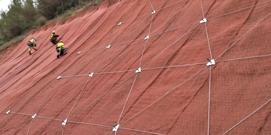
The drill rig sits on the crest of a Red Deer River valley slope, rotary head spinning. Crews pull Shelby tubes from the stiff glacial till while an inclinometer casing gets installed twenty metres into the formation. This isn't a generic site investigation. The geomorphology here demands specific instrumentation. Red Deer sits astride deeply incised river valleys with up to 40 metres of relief, and the surficial geology shifts from ablation till to glaciolacustrine silt within a few hundred lateral metres.
A proper slope stability analysis in this setting requires pore pressure measurement, shear strength testing on undisturbed samples, and a factor-of-safety calculation that accounts for rapid drawdown conditions along the Red Deer River. The triaxial testing program establishes effective stress parameters for the till, while in-situ permeability measurements quantify the drainage characteristics that control pore pressure response during spring melt.

A slope that stands at 1.5:1 in dry summer may fail at the same geometry come April, and the difference is entirely in the pore pressure distribution.

Our service areas

Methodology and scope

A recurring mistake we see in Red Deer is treating all coulee slopes as if they're homogenous clay banks. They aren't. The surficial units above bedrock include preglacial gravels, multiple till sheets, and intra-till sand lenses that act as perched aquifers. When a contractor excavates a toe cut without identifying these lenses, they trigger a drainage path that saturates the lower slope and drops the factor of safety below 1.0 within days.
The stability model must incorporate layered stratigraphy, and that means test pits to log the near-surface sequence and geophysical profiling to map the bedrock contact. We run limit-equilibrium analyses in Slide2 or SLOPE/W, back-analysing existing failures along the Red Deer escarpment to calibrate strength parameters. The output is a design recommendation for benching angles, subdrain placement, or structural reinforcement that stays within the City of Red Deer's setback requirements for valley slopes.
Slope Stability Analysis in Red Deer – Geotechnical Risk Assessment
Technical reference — Red Deer

Site-specific factors

One pattern that repeats across Red Deer's older subdivisions is basement seepage appearing years before the slope actually moves. Homeowners report water in window wells every spring, and nobody connects it to the twelve-metre escarpment behind the property. That seepage is the first signal that pore pressures are building along a silt seam. By the time tension cracks open at the crest, the failure surface is already fully defined and the slide mass is moving at millimetres per day.
The most dangerous scenario here is a retrogressive failure in glaciolacustrine silt—it starts small at the toe, then steps backward in rotational blocks until it undercuts a house foundation. We've mapped these failure sequences along Piper Creek and Waskasoo Creek. A preventive stability assessment costs a fraction of what emergency slope remediation runs once the scarp reaches the property line.

Need a geotechnical assessment?

Reply within 24h.

Email: info@geotechnicalengineering.xyz

Applicable standards

NBCC 2020 (National Building Code of Canada – seismic hazard, limit states design), CSA A23.3 (Design of concrete structures – retaining elements in slope stabilization), ASTM D4767 (Consolidated-undrained triaxial compression test on cohesive soils), ASTM D1586 (Standard penetration test – overburden correction for strength profiling)

Technical data

ParameterTypical value
Minimum factor of safety (static, long-term)1.5
Minimum factor of safety (pseudo-static, seismic)1.1
Typical slope height analysed8 to 45 m
Shear strength test standardASTM D4767 (CIU triaxial)
Groundwater monitoring durationMinimum 6 months (piezometer)
Seismic hazard zone (NBCC 2020)PGA 0.05–0.10 g
Software platformsSlide2 / SLOPE/W / PLAXIS 2D

Frequently asked questions

What triggers slope failures in the Red Deer River valley?

The dominant trigger is elevated pore water pressure from snowmelt infiltration and heavy summer rain events. Undercutting by the river during high-flow periods also removes toe support. Less common but relevant is human activity—uncontrolled fill placement at the crest or excavation at the toe without drainage provisions.

How long does a stability analysis take for a residential lot backing onto a coulee?

A complete assessment typically spans three to five weeks. The field program—drilling, sampling, piezometer installation—takes one week. Triaxial testing requires two to three weeks for consolidation and shear phases. Modelling and reporting add another week.

What does a slope stability study cost in Red Deer?

Costs range from CA$1,540 for a desktop review of an existing slope to CA$6,020 for a full investigation with drilling, lab testing, instrumentation, and limit-equilibrium modelling.

Does the City of Red Deer require a slope stability report for building permits near valley slopes?

Yes. Properties within the Environmental Reserve setback or within a defined hazard area typically require a geotechnical assessment signed by a professional engineer licensed in Alberta. The report must demonstrate a minimum factor of safety under both static and seismic conditions per the current building code.

Location and service area

We serve projects in Red Deer and surrounding areas.

View larger map